We support our Publishers and Content Creators. You can view this story on their website by CLICKING HERE.
As the Palisades Fire continues to burn in Los Angeles County, California, aerial images of Pacific Palisades are coming in showing the scope of the destruction.
Advertisement
ABC Los Angeles posted the photos Thursday morning:
#Palisades there is just no words … #palisadesfire pic.twitter.com/a2zcefU6p1
— Marcel M (@marcel_cameraop) January 9, 2025
NBC LA also posted drone video:
SHOCKING: New drone footage shows the complete devastation and destruction from the Pacific Palisades Fire as @NBCLA reports at least one killed from the blaze
Video: Matthew Heller pic.twitter.com/y3xYJSkvmS
— Jacob Wheeler (@JWheelertv) January 9, 2025
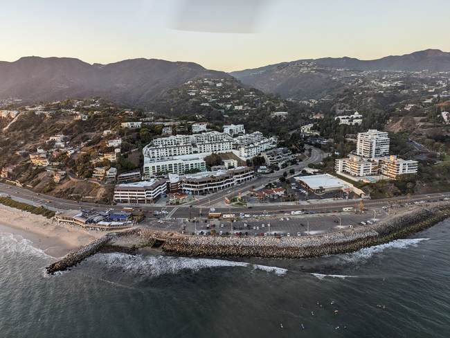
These images are a stark contrast for those who know the area well. I’ve flown over the area in a helicopter on a few occasions courtesy of Group 3 Aviation, based at Van Nuys Airport. This photo of the intersection of Pacific Coast Highway and Sunset Boulevard was taken on September 28, 2022.

Here is that area Thursday night:
HAPPENING NOW: #PalisadesFire A graveyard of cars, some burned to a crisp! An apocalyptic scene here on Sunset Boulevard above PCH. pic.twitter.com/mz5uyHmrrC
— Alexandra Datig | Front Page Index 🇺🇸 (@alexdatig) January 9, 2025
Advertisement
The aerial photos and videos come amid reports of human remains found in multiple homes charred by the Palisades Fire.
BREAKING: LA County Sheriff’s Dept has received a report of a 4th location where possible human remains have been found in connection with #PalisadesFire
Meanwhile, the Medical Examiner is picking up remains they believe are of homeowner who died in their Malibu home. @FOXLA pic.twitter.com/dVmyaSPTl7— Gigi Graciette (@GigiGraciette) January 9, 2025

 Conservative
  Search
 Trending
 Current News


