 Conservative
  Search
 Trending
 Current News
We support our Publishers and Content Creators. You can view this story on their website by CLICKING HERE.

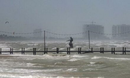
The National Weather Service in Tampa on Wednesday night issued a rare “extreme winds” warning, as the most dangerous part of Hurricane Milton creeps in Florida.
The hurricane remains a Category 3 storm with wind gusts of up to 120 mph, and the eye of the hurricane is still approximately 30 miles from Tampa and Sarasota, according to CNN. Landfall is established when more than half of the hurricane’s eye is over the mainland.
The weather service said that the entire Tampa area is now under the warning, and ordered residents still in the area to take shelter immediately because it is a life-and-death situation.
“Treat these imminent extreme winds as if a tornado was approaching and move immediately to the safe room in your shelter NOW,” the Tampa National Weather Service warned. “Take action now to protect your life!”
The extreme wind warning is in effect until 9:30 p.m. Eastern.
Manatee and Pinellas Counties have also suspended their emergency services because of the weather. Both are in Milton’s path.
“Due to hazardous conditions,” an alert from Manatee County read, per CNN. “Emergency services are suspended. 911 calls will be logged for when service is safe to perform.”
The developments come after the state issues more than 50 tornado warnings as of 3 p.m., with at least 18 confirmed tornadoes being spotted so far. The bulk of the tornado warnings were issued in Miami.
Misty Severi is an evening news reporter for Just The News. You can follow her on X for more coverage.