
 Conservative
  Search
 Trending
 Current News
We support our Publishers and Content Creators. You can view this story on their website by CLICKING HERE.
Conservative Jews who support Israel are known to complain that, while the League of Nations created a jurisdiction called “Palestine” in 1922 to give life to the Balfour Declaration of 1917, the League wound up giving 77% to the Arabs (i.e., what became in 1946 the Hashemite Kingdom of Jordan). This narrative is true according to the League’s map of Palestine—except that map is a fraud, and we know that by comparing it to maps of “Palestine” as it was known before World War I. However, there’s much more to the story of who’s occupying what land.
Here’s the surprising truth: While Israel is slandered today for ruling in allegedly “Occupied Palestinian Territory,” the cartographical record makes clear that three Arab states are occupying 53% of the classical map of the Holy Land (not to be confused with the fraudulent Mandate map). Any time these three want to create a new “Palestinian” state in historic Palestine, they can. Israel would not stop them and would not have to retreat from any of the land it captured in self-defense in 1967.
The most authoritative map of Palestine is found in the 11th edition of the Encyclopedia Britannica, published in 1911.
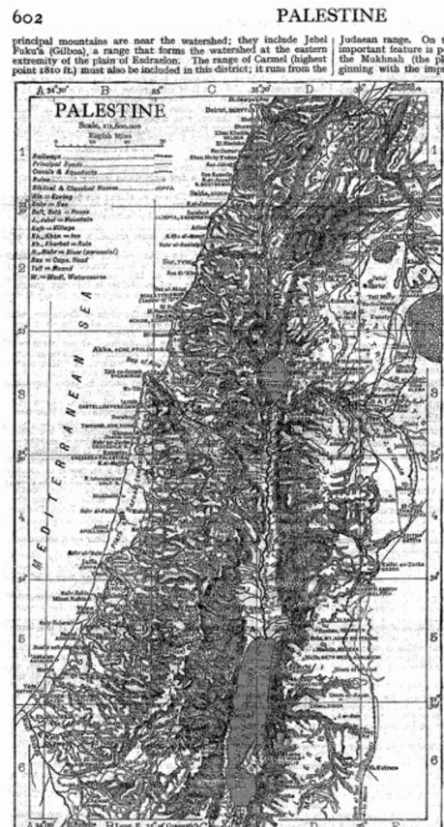
Image courtesy of Sha’i ben-Tekoa.
Encyclopedia aficionados judge this to be the best map ever. It is likely that this very map is what Prime Minister Lloyd George and Foreign Secretary Arthur Balfour studied in 1917 before issuing the letter expressing British support for the Zionist Jews who were already a decade into their project to restore the barren wastes of the Bible’s Promised Land as a homeland for the persecuted Jewish people.
This map, curiously, used to be available in the online version of that famous edition. Later, however, it was mysteriously removed, presumably because someone did not want the world to see it. It is now available only in moldering, hard-cover versions in libraries worldwide.
The map is clearly based on the Jewish Bible, which contains verbal descriptions of the Promised Land (to which the Romans later gave the antisemitic name “Palestine”). For example, the Holy Land’s western boundary is so old that it dates to the age of the Great Flood. In Genesis 9:18, the narrative picks up after the Flood with Noah and his three sons, “Shem, Ham and Japhet—Ham being the father of Canaan.” By verse 10:15, “Canaan begot Sidon his firstborn…and the Canaanite boundary extended from Sidon going toward Gerar, as far as Gaza…”
This is the shoreline of the modern State of Israel—almost. Sidon was a port then and still is, and so is Gaza, which is 160 miles / 256 kilometers down the coast. That was the geography when Moses transcribed the first five Biblical books, and it is the same seashore today, only now Sidon is located in the Arab-majority state of Lebanon.
At the end of Genesis, the aged Patriarch Jacob, on his deathbed, speaks his last to his sons, giving each his inheritance (49:13): “Zebulon shall settle by seashores. He shall be at the ship’s harbor, and his last border will reach Sidon.”
This is the second time Sidon is cited as a boundary town. This means that, in the 21st century, Lebanon is as much in “occupation of Palestinian territory” as Israel is accused of being.
Moreover, the historically accurate Britannica map does not show the Jordan River as the eastern boundary of “Palestine.” In truth, the river is almost in the middle of historic Palestine because the Bible makes clear that the land 35 miles east of the river was also destined for the Israelites. It was common in the early 20th century to refer to Palestine west of the Jordan as Cis-Jordan, as opposed to Eastern Palestine (later Trans-Jordan) on the other side.
The Bible’s fourth book, Numbers 34:1-12, contains an even more extensive word-map of land slated for the Israelites on the east bank and beyond.
The Britannica’s article on “Palestine” also states clearly that, in 1911, there was no extant geographical entity/polity called “Palestine.” The Muslims had ruled the region for twelve of the previous fourteen centuries and never knew of any country called Filistin. The encyclopedia said this map was not that of an existing country/state.
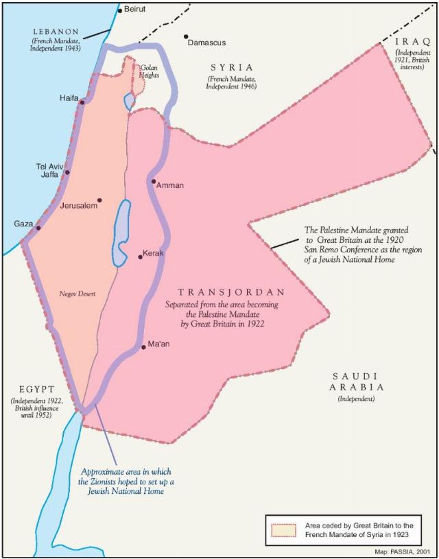
Now, consider the League’s Palestine Mandate map of 1922, the text of which paved the way for transforming Eastern Palestine into an Arab state, something that pleased King Faisal of Mecca.
Faisal, unlike contemporary Arab Muslims, supported the tiny Jewish state’s “from the river to the sea” because he believed it would bring progress to the Arab world.
In the League’s map, not only has the land that is now modern southern Lebanon disappeared from Palestine (it was handed to the French), but the Jordan River has been turned into the Jews’ proposed eastern boundary. All Eastern Palestine was to be cut off and slated for Arab ownership and rule, and that is what happened.
Most egregiously, the League’s boundary of eastern Palestine was pushed way out to annex that obviously unnatural, artificial, geometric bulge in modern Jordan that never was Palestine.
When the Paris Peace Conference opened on January 3, 1919, all involved assumed that the Brits would push to implement their Balfour Declaration. However, this enraged the leader of the Arabs in Jerusalem, the Grand Mufti Haj Amin al-Husseini. Haj Amin was adamantly and murderously opposed to a mandate that also identified “Palestine” as the “historic homeland of the Jews.”
In October 1919, he began publishing a newspaper in Jerusalem that he called Al-Suria al-Janubia/ Southern Syria. Its purpose was to combat the League’s plan to create a new jurisdiction called “Palestine.” Only Jews and Christians knew Palestine as a synonym for the Bible’s Promised Land. Haj Amin, however, insisted there never was such a country—and when it came to Islamic history, he was right.
On March 12, 1921—a year before the Palestine Mandate text was completed—British Colonial Secretary Winston Churchill met in Cairo with men from the Foreign Office, the Colonial Office, and the British Army, including High Commissioner in Palestine Herbert Samuel and Col. T.E. Lawrence (“of Arabia”) to discuss the Middle East’s future. They had just received fresh intelligence that Abdallah, brother to their ally Faisal, was marching northward from the Hedjaz toward Damascus with a force of three hundred tribesmen.
Abdallah’s goal was to drive out the French with whom the British were allied. Churchill decided to bribe Faisal with a state of his own as a reward for not attacking Damascus. The bribe took the form of that ridiculous, obviously unnatural extension that is eastern Jordan. Faisal had no conception of the boundaries of Palestine/the Promised Land and could be convinced he was getting 77% of it.
The net result was that Lebanon, Syria, and Jordan collectively wound up with 53% of the Britannica’s historically accurate map.
Here is a black and white Biblical map (using a less detailed version than the Britannica’s) that has been computer-enhanced to show how, since 1922, most of historic Palestine has been divided among Israel and three Arab states, which means the delusional, antisemitic Two-State Solution is really a Five-State Solution, each with a piece of the Jews’ Biblical Promised Land.
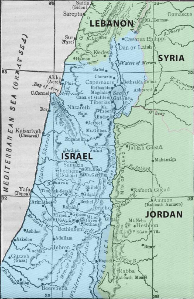
Image courtesy of Sha’i ben-Tekoa.
In any case, any time the governments in Beirut, Damascus, and Amman, which allegedly care so deeply for their putatively primeval “Palestinian” brethren and want to create a state just for them on aboriginal Palestinian land, all they have to do is hand over the 53% they have been in occupation of since the 1940s.
And Israel retains all the land it now rules over “from the river to the sea.”
Sha’i ben-Tekoa’s PHANTOM NATION: Inventing the “Palestinians” as the Obstacle to Peace is available at Amazon.com in hard cover or a Kindle ebook. His podcasts can be heard on www.phantom-nation.com.